SEG 2020 Workshop: Underground Water and Karst Imaging, 28 August 2020, Virtual
https://doi.org/10.1190/uwki2020_13.1
Abstract
The water inrush is one of the most dangerous geological disaster in underground engineering. Detecting and forecasting the underground water-bearing structures are critically important for preventing the occurrence of water inrush hazards. Due to the complexity of geological structure and multiplicity of solutions from single geophysical technique, integrated geophysical methods and complexified acquisition setups need to be used for getting high-resolution imaging of subsurface. Here two case studies are presented to show the importance and necessity of high resolution geophysical methods for underground water detecting.
Introduction
The focus of tunnel construction gradually shifted to the western China in last decade. Deep buried long tunnel projects increased rapidly because of the complex topographical conditions in this area, and some tunnels can be more than 10 km long and 1 km deep (He and Wang, 2013). Meanwhile, the complex geological conditions in this area also made those geological abnormal bodies difficult to be investigated, such as fault, karst cave, fracture zone, etc. If these geological abnormal bodies get saturated (becoming to the underground water-bearing structures) which is quite easy in western mountainarea of China, they have the potential to cause geological hazards for example the water inrush (Li et al., 2014).
The existence and migration of groundwater is mainly reflected in the change of resistivity of subsurface media (Li et al., 2015). Therefore, in order to effectively control or avoid water inrush, high resolution geophysical methods need to be used to accurately determine size and range of the geological abnormal bodies before tunnels construction. However, current initial exploration work before tunnel construction is quite rough. People are deeply relied on the advance geological prediction technology in the tunnels such as GPR, TEM, direct current (DC) resistivity and pilot hole (Shi et al., 2020). These methods can not give a fully understanding of groundwater especially the distribution of the whole system.
Next, two case studies will be presented to show the importance and necessity of high resolution geophysical methods for underground water detecting. Here the high resolution geophysical methods means the integrated geophysical methods (use two or more combination of ERT, CSAMT and drilling etc.) or the complexified acquisition setups such as the 3D survey layout.
Case one
A extra long separated highway tunnel is located at southwest of Yunnan province, and the length and depth of this tunnel reaches up to 10.2 km and 1.2 km, respectively. Two CASMT high-resolution profiles were collected along the radial direction of the tunnel for both left and right side. At the mileage from K13+500 to K13+700 a low resistivity abnormal area was found in the apparent resistivity result of the right side tunnel, meanwhile, an inferred fault passes through the same area (see figure 1).
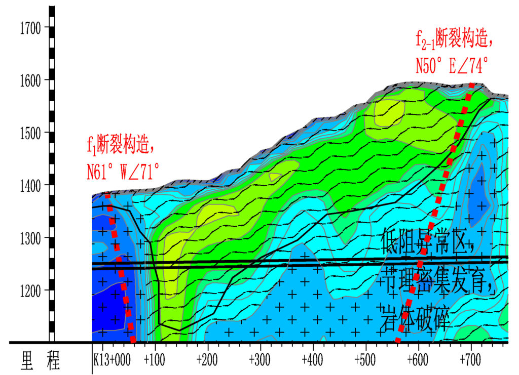
The high-precision detection result of the subsurface indecated that this area has highly potential to induce the water inrush and an early warning has been proposed. On September someday, 2019, the water inrush occured at the mileage of K13+612.4 and in next 3 days the total volume of mud inrush reaches to 9400 m3 and the maximum water flow reaches to 100 m3/h. Due to the early warning no one was killed in this disaster.
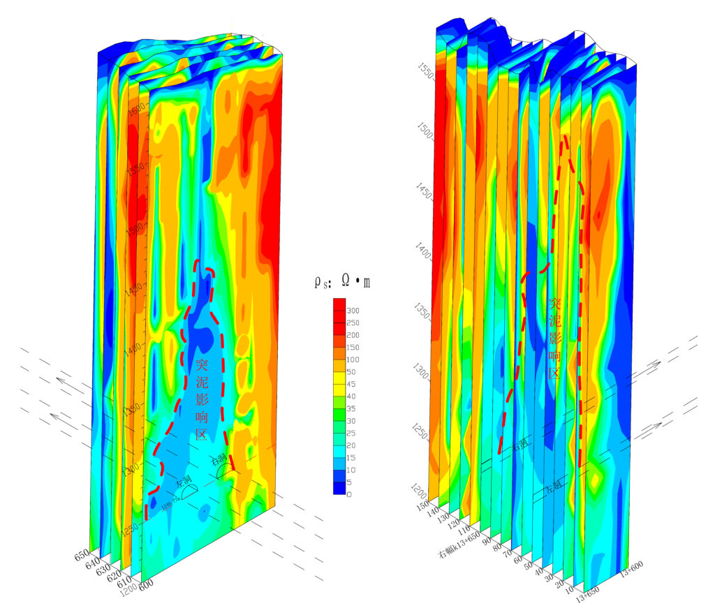
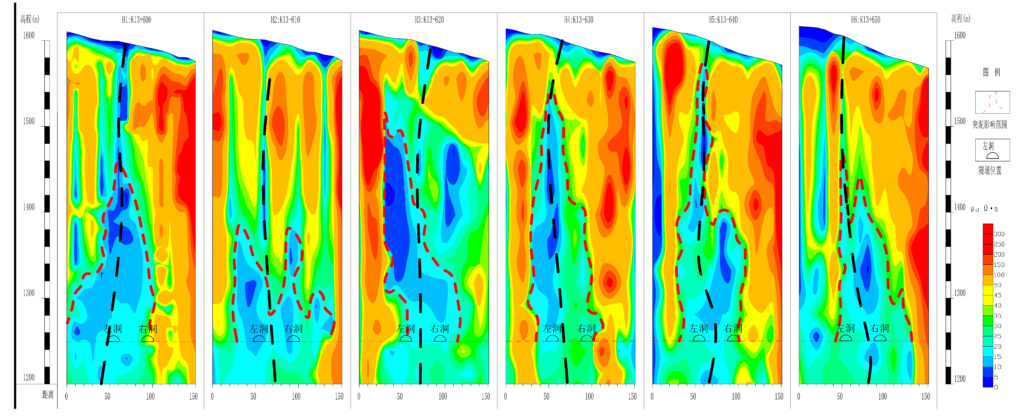
In order to get more precise imaging of the underground water and investigate the distribution of the whole system in this area, a 3D CSAMT survey was implemented (figure 2). 6 transverse lines and 16 longitudinal lines formed total 96 observation points. The quasi 3D imaging results by using 2D apparent resistivity profiles show the saturated zone of the low resistivity abnormal area (figure 3), which also indecate the source of the underground water mainly comes from the surface. In figure 4 we observed that the surface water seeps to underground alongthe fault.

To sum up, we should realize that it is quite important to implement high resolution geophysical methods before tunnels construction through this case. If the 3D CSAMT survey can be done earlier, we have a great possibility to reduce the losses caused by water inrush by taking some measures for example drilling the water diversion holes.
Case two
A positive example has been presented above which incated the effectiveness of the high resolution geophysical methods in underground water detection, however, a negative example will be presented next. This tunnel located at the area less than 100 km away from the previous case, and the scale is smaller compared to the previous one (the length and depth are 5.3 km and 0.45 km, respectively). On November some day, 2019, the water inrush occured at the mileage of K42+950 and the total volume of mud inrush reaches to 15 000 m3 in several hours. Becasue there is no early warning, 12 people died in the disaster.
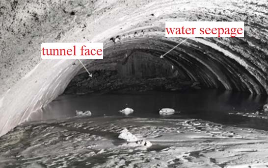
Post-disaster investigation shows that both the advance geological prediction and the tunnel construction process are strictly following the standards. Even 3 pilot holes have been drilled before the water inrush occured. But no one has predicted the disaster, because either advance geological prediction or pilot hole can only give informations in front of the tunnel face, however, the water inrush came from the topside of tunnel face (see figure 5).
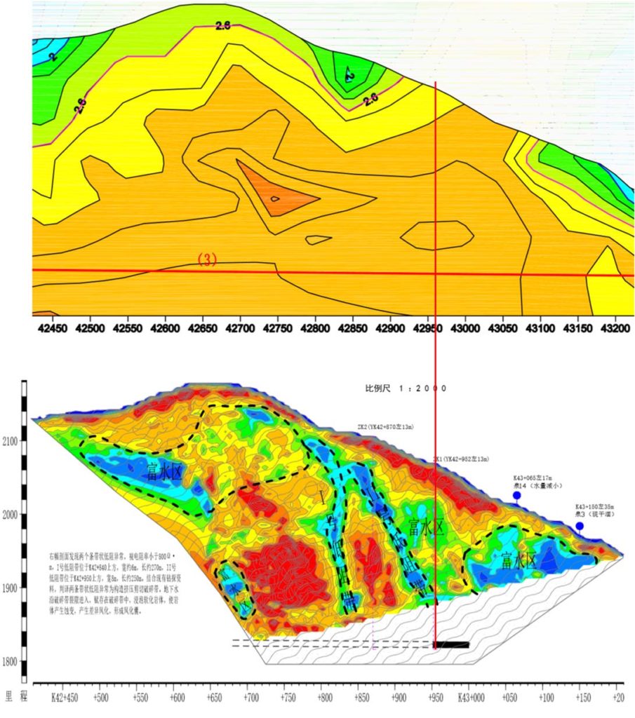
In order to figure out the reason of the hazard, a high-density and -power ERT method, two deep drills and 3D advance geological prediction methods in tunnel have been implemented at the water inrush area. And there are huge differences between the ERT result and the initial exploration data (see figure 6). There is in barely nothing can be seen in initial exploration data, the homogeneous area indecated that there is nothing need to be noticed. However, two very clear underground water channels can be observed in ERT result and one of them directly points to the water inrush area of tunnel.
Moreover, combined the informations from ERT, drilling holes and 3D advance geological prediction methods in tunnel, the size, location and scale of the collapse body can be described precisely (see figure 7). Which again indecates the importance and necessity of high resolution geophysical methods for underground water detecting before tunnels construction.

Conclusions
Currently, people are deeply relied on the advance geological prediction technology in the tunnels and ignore the important role of the initial exploration work before tunnel construction. Here, two case studies have been presented to show how the high resolution geophysical methods can help to provide the high-precision detection results of the subsurface. And the importance of knowing the distribution of the underground water system before tunnels construction. An early warning can avoid the equipment damage, project delay, and even casualties.
References
He, C., and B. Wang, 2013, Research progress and development trends of highway tunnels in china: Journal of Modern Transportation, 21, 209–23.
Li, S., B. Liu, L. Nie, Z. Liu, M. Tian, S. Wang, M. Su,and Q. Guo, 2015, Detecting and monitoring of water inrush in tunnels and coal mines using direct current resistivity method: A review: Journal of Rock Mechanics and Geotechnical Engineering, 7, 469–478.
Li, S., B. Liu, H. Sun, L. Nie, S. Zhong, M. Su, X. Li, andZ. Xu, 2014, State of art and trends of advanced geological prediction in tunnel construction: Chinese Journal of Rock Mechanics and Engineering, 33, 1090–1113.
Shi, S., X. Xie, S. Tian, Z. Wen, L. Bu, Z. Zhou, S. Song, and R. Zhao, 2020, Advanced geological prediction, in Tunnel Engineering: IntechOpen, 2.